Deep Dive into State-of-the-Art LiDAR: RIEGL Demo Day Tallinn
April 22, 2026 | Paljassaare laht & Fotografiska, Tallinn
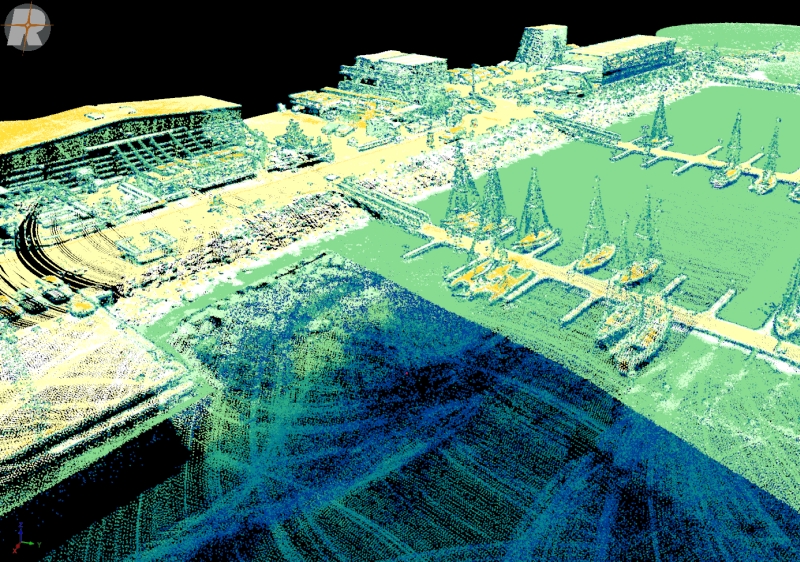
RIEGL VUX-820-G – Bathymetric Survey
High-performance bathymetric LiDAR
shallow water mapping
coastal zone mapping
navigation
environmental monitoring
RIEGL VUX-160 – Topographic NFB Lidar
High-performance infrared LiDAR
NFB (Nadir/Forward/Backward)
PRR 2.4 MHz
Complete coverage of complex structures
forest / terrain
What to expect:
You will see firsthand how the RIEGL VUX-820-G measures shallow waters and how the RIEGL VUX-160’s NFB scanning pattern provides complete coverage for infrastructure and terrain mapping. The laser scanners are installed on a Acecore Noa drone.
In the afternoon, at Tallinn Fotografiska, you can see what the data looks like. Our experts will be on-site to answer technical questions and discuss how these solutions can be integrated into your professional workflow.
Important Note: As this is an outdoor field demonstration in the morning, please dress according to the weather conditions on the coast.
Event Details:
Date: April 22, 2026 starting around 8:30 in the morning.
Location: Paljassaare laht, Tallinn. You will get detailed info where to arrive closer to the date.
Data presentation: Fotografiska, Tallinn. In the afternoon – You will get detailed info about the time closer to the date.
More information?
If you have further questions, please contact us.